Giant’s Causeway: A Stone Pavement Nobody Built
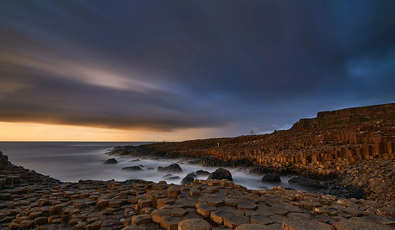
Giant’s Causeway at dusk, photographed with a long exposure that smooths the sea. Thomas Fuhrmann / SnowmanStudios, “Giant’s Causeway at dusk 04,” via Wikimedia Commons, CC BY-SA 4.0; converted to WebP.
- Where is the Giant’s Causeway, and what are we looking at?
- How does lava turn into something this orderly?
- Look closer: the pattern is not a perfect hexagon factory
- Now turn the “pavement” into a three-dimensional landscape
- And the giant? Keep the story, but label it properly
- The souvenir the rocks definitely do not need
- How to enjoy it without chasing an impossible photograph
- Cover photograph and image rights
If this pattern appeared outside a café, you might ask who laid the paving. At the Giant’s Causeway, the more surprising answer is that nobody did. The fitted-looking stones are the tops of natural basalt columns, made when ancient lava cooled and cracked.
On the Antrim coast of Northern Ireland, those columns meet the Atlantic in a scene that looks somewhere between a staircase, a honeycomb, and the unfinished project of a very ambitious builder. Its appeal is not only that it looks strange. Once you know what to notice, the landscape starts explaining itself.
Here is a way to enjoy the real place behind the famous photograph: read the shapes, separate the geology from the giant story, and leave with better observations—not a coin wedged into the rocks.
Where is the Giant’s Causeway, and what are we looking at?
UNESCO describes the Giant’s Causeway and Causeway Coast as a volcanic landscape with roughly 40,000 basalt columns, below the cliffs at the edge of the Antrim plateau. Its rocks record events tens of millions of years ago; this is not a modern coastal construction.
The useful word is column. You are not looking at a collection of little tiles laid on a beach. In many views, you see the ends of much longer pieces of rock. That difference is what turns a pretty pattern into a much better puzzle.
How does lava turn into something this orderly?
The process is called columnar jointing. As the rock cools, it contracts; stress produces cracks that extend into it. Oregon State University’s Volcano World explains that the columns develop perpendicular to the cooling surface. The boundaries are fractures in rock, not joints filled by a mason.
A helpful way to picture it is to stop imagining separate blocks being placed together. The British Geological Survey describes contraction cracks passing through a body of cooling lava. Imagine that material being divided by a growing network: the gaps define the columns. The apparently constructed result comes from the way the rock separates.
Then ask two different questions: how did the columns form, and why can we see so many of them now? The National Trust’s formation history describes cooling lava as well as later erosion that exposed the columns. The sea did not carefully carve every hexagon into an otherwise ordinary slab.
Look closer: the pattern is not a perfect hexagon factory

“Hexagonal” is a useful first impression, not a promise about every stone. Northern Ireland’s environment department records columns with other numbers of sides, as well as curved, interlocking surfaces at joints within the columns.
Try a small looking exercise with the photograph above. Choose a top whose edges are clear, count them, then choose its neighbor. Move between the outline, the shallow pool, and the side face. Some edges are difficult to distinguish because of wear, water, or perspective; uncertainty is a better answer than forcing every outline to be a hexagon.
That is part of the pleasure here. The overall rhythm looks almost designed, while the individual details refuse to behave like identical products from a mold.
Now turn the “pavement” into a three-dimensional landscape

The formation known as the Organ Pipes makes the vertical dimension much easier to see. The National Trust’s history page also highlights these long, pipe-like rocks. Compare them with the low tops beside the sea: a change in viewpoint changes what your brain thinks the pattern is.
You can use three questions to look at the photographs without turning the visit into a geology exam:
- Am I seeing a top or a side? This is the quickest way to stop reading every surface as a floor.
- Where does the rhythm change? Notice a low cluster, a taller run, or a rougher patch rather than treating the whole coast as one repeated texture.
- What gives the scene scale? A column can dominate a close view, while a broad coastal view puts it back into its setting.
None of these questions requires climbing higher or moving closer to the water. A viewpoint is useful only when it is safe and permitted.
And the giant? Keep the story, but label it properly
In one legend retold by the National Trust, the Irish giant Finn McCool builds a route across the sea to confront the Scottish giant Benandonner. The rival’s retreat leaves a broken causeway behind. It is folklore, not the geological explanation.
The story works because the landscape almost invites it. “Someone enormous must have made this” is an understandable imaginative response to an unfamiliar pattern. You can enjoy that response without confusing a memorable name with evidence of a human—or giant—builder.
Try asking a child, or simply yourself, to describe the scene before revealing the explanation. A staircase? A game board? A row of seats? Then introduce the cooling cracks. The real answer does not make the place less playful.
The souvenir the rocks definitely do not need
A small coin can look harmless beside an enormous landscape. The National Trust reports that coins wedged into the cracks corrode and expand, damaging the basalt and leaving stains. Its request is straightforward: stop putting coins into the stone and leave no trace.
Do not try to “help” by prying existing coins out yourself. Leave conservation work to the people responsible for the site. A photograph, a sketch, or a note about one surprising shape is a better way to mark your visit than leaving something behind.
How to enjoy it without chasing an impossible photograph
Start with the official visitor information when planning a trip; check current access, facilities, and arrangements rather than relying on an old price list. The Blue Trail guidance warns that wet stones can be slippery and dangerous and says to follow rangers’ advice. A convenient-looking stone is not automatically a safe next step.
The cover photograph is a long exposure: the file records 119 seconds. That helps explain the smooth-looking water. It is a photograph of movement gathered over time, not proof that the sea was a calm floor you could approach safely.
For your own pictures, think in terms of a small visual story from permitted viewpoints: one broad setting, one group of repeating shapes, and one detail. You do not need the exact cover angle, an empty site, or a risky position at the water’s edge to make the place interesting.
If landscapes that resemble something else appeal to you, explore Uyuni’s reflection of the sky and Pamukkale’s white terraces. The reward is not only collecting unusual destinations. It is learning to ask a better question when a real place looks almost unreal.
Cover photograph and image rights
Cover: Thomas Fuhrmann / SnowmanStudios, “Giant’s Causeway at dusk 04,” via Wikimedia Commons, CC BY-SA 4.0. Our WebP copy retains that license. The two body photographs have their own credits and licenses in the captions. These are earlier photographs by the credited creators, not a report of a Dajran visit.

These are real photographs from earlier years, not AI-generated images or a report of current sea conditions. Preparation used proportional resizing where needed and WebP conversion, without cropping the frames or adding elements. Both language versions use the same images, which retain the licenses stated above.